
January 11th – We arrived at the office of the Archaeology Commission on Rhodes at about 9 AM for a meeting with the Greek officials to pick up our research permit. Part of this meeting also involved laying future groundwork for additional studies we want to complete in Rhodes in the future. The meetings lasted two hours and we left the meeting with our permits and a plan for the completion of our research design over the next week. We still needed to complete GPR analysis at Kahal Shalom. Last year the GPR transects covered about half of the floor area in the main synagogue building. This year’s plan was to complete the analysis of the other half of the synagogue building, and to collect data from the courtyard outside the main synagogue building. My part of this work included merging this year’s spatial data base with last year’s data base. We are also to complete additional work at the Grand Masters Palace. At the Grand Masters we completed a set of GPR transects in the open area outside of the main palace walls. This year we will continue that set of transects across this open area right up to the walls of the Grand Master. Additionally, we will complete a set of transects behind the palace in an area where a Byzantine era tower existed. Finding the Byzantine walls and towers are important in the search for Hellenistic era features. The Byzantine features pre-date the Hellenistic features by about 700 years, but it is very likely that the newer Byzantine features followed the trend of the older Hellenistic features. We have located Byzantine era walls that were exposed at the surface by past excavation and in the existing walls of the Grand Master Palace. In some locations the Byzantine walls form the base of the Grand Master walls. The GPR also located anomalies in the open area outside of the Palace walls that are interpreted to be Byzantine walls. Another area where work will be completed is Kahal Grande. Like Kahal Shalom, the GPR line at Kahal Grande only covered about 50% of the exposed floor of the old synagogue. The plan for this year was to complete the other 50% and to then lay out a set of transects perpendicular to the other transect, hence forming a grid. Collecting GPR data from a grid allows the data to be modeled in three-dimensions. Lastly, we were to continue to collect GPR and spatial data at the Church of the Victory. Last year we collected GPR data from one set of transects and this data did not indicate any anomalies in the subsurface. The plan this year is to collected data from different transects in the vicinity of the ruined church and to collected data from two GPR grids as well.
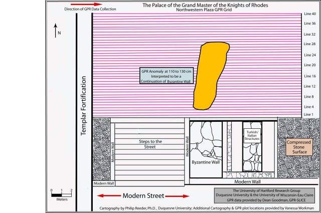
After the meetings with the commission we went to the Grand Masters Palace to continue the GPR transect from last year. Last year we were able to locate a sizable length of what we suspect is the Byzantine era wall several meters beneath the open area at the palace. The map created last year is presented below which shows the Byzantine wall. We are scheduled to have a dinner meeting with the city architect and his wife tonight. His wife wrote her doctoral dissertation on locating the Colossus and the plan is for her to meet us tomorrow to show use where she thinks the base of the Colossus is located now under the palace.
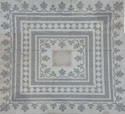
January 12th – We spent the morning at Kahal Grande. The first part of the research design at Kahal Grande involves completing the second 50% of the set of transects from January 2015. This involved collecting the spatial data to allow the map of Kaha Grande to be updated. Also, locations for eventual fiberscope analysis were located. These are locations where a fiberscope can be inserted to possibly see any structural materials beneath the current floor. The data collected today showed an anomaly located beneath a unique tile pattern on the floor. In future days before our departure on January 17th, a hole may be drilled in the vicinity of this feature so that an possible structures beneath this location can be possibly viewed. Shown below is the updated map of the Kahal Grande with the fiberscope locations noted, the expanded transect lines and GPR grid added and the unique floor design placed in the proper location. Also presented below is a photo of the unique floor design under which the anomaly is located.

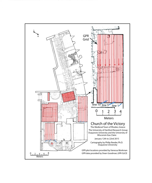
January 13th – Today we started work in the morning at the Church of the Victory. When we met with the town architect on Monday night he indicated several locations at the ruins of the church where he thought walls of the older Jewish synagogue located beneath the ruins of the Church of the Victory could be found. Additional transect lines were laid out and GPR grids were created in two locations. The updated map of the Church of the Victory is presented below. The GPR data from these locations is still being analyzed and I will add it to the blog later in the week when the data is ready.
In the afternoon we went back to the Grand Masters Palace to complete GPR analysis in the vicinity of where a Byzantine tower was possibly located. As previously noted, the Grand Masters Place in places used the old Byzantine walls as the base of new walls for the palace. Such a location is depicted below. It is hypothesized that this Byzantine wall was the base of the Byzantine tower. It is further hypothesized that the Byzantine tower was built at the location where the Colossus of Rhodes once stood. Below is a photograph of GPR data being collected in the vicinity of Byzantine tower location at the Grand Master Palace. I heard an interesting story while collecting spatial data at this location today. Below is a photo of Richard Freund standing next to a very large rock. This rock was collected from the sea floor in the harbor. In the late 1980’s a psychic said that she could see the hand of Colossus at the harbor. Dredging eventually found this rock. The grooves in the rock were said to be the fingers of the Colossus. The rock was hauled to the Grand Masters Palace for display. Eventually, study by geologists and historians refuted that the rock had anything to do with Colossus, and the story was essential forgotten and the rock is now tucked away in a storage area of the palace grounds.


January 14th – The morning was well spent at two locations. First, I met with one of the archaeologists. I was given access to five bags of bones that were collected on the south end of Rhodes Island at an early Christian burial site. I randomly selected a total of 15 bones from the five bags. These bones will be transported back to Duquesne University and they will be preliminary analyzed in the DNA Analysis Lab. It will be determined first if there is extractable DNA and the if yes, the DNA will be analyzed. These preliminary analyses may serve as a preliminary step in the development of a much larger project in cooperation with the Greek Archaeology Commission. The purpose of this project will be to develop a ancient DNA data base for the island of Rhodes. Depicted below are five bones collected from one of the bags. In the afternoon the research team received a guided tour of the Archaeology Museum of Rhodes. The museum possesses a fantastic collection of artifacts spanning the long history of the island.

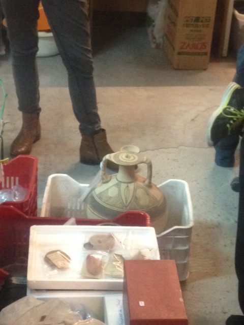
January 15th – The morning was spent at two locations. First we spent time visiting the XRF team that is working at Archaeology Commission laboratory for the past four days. They are working on a project using the XRF to scan each artifact in the collection of oil lamps that the commission possesses. The XRF quantifies the type and percentage of each mineral that makes up the artifacts. In this way each mineral is quantified and comparisons can then be made between artifacts and time periods to uncover information about changes in mineral composition through time and perhaps ancient trade practices. The team working on this part of the research design for this project has been so efficient that they have completed the collection of oil lamps and have moved on to other vessels. Depicted below is a fantastic vessel. This is a Bronze Age pot, most likely used to store oil that is from 2,400 BC. It was collected intact, as shown in the photo. This is a magnificent piece of history. Also depicted below is the XRF team in action. At this point they have scanned and photographed over 150 artifacts. Our goal was 125, so we are very pleased with how this segment of the project is going. As an aside, there is a photograph below of Dr. Harry Jol in one of the archive rooms of the Archaeological Commission. As you can see, they still store a lot of this data in paper form.


The afternoon was spent back at Kahal Shalom shooting GPR in the back courtyard at the synagogue. Several holes were also drilled in the floor at the locations of GPR anomalies and the fiberscope was used to view is the holes intersected any underlying structures. In this case nothing could be seen.
